Flamingo Shangri-la

At Laguna Roja in the Atacama, we were treated to flamingos – literally thousands and thousands of them in various states of activity. Some partook of the algae that gives them their pink color, while others seemed to be gossiping by the water cooler. We caught others in various states of arrival and departure – as you may be able to see here, they take several steps across the water at takeoff and landing.

I’m not typically much of a bird fan, but they had to pry us away to continue on our journey.

20120327-225639.jpg

20120327-225611.jpg

20120327-225651.jpg

20120327-225702.jpg

20120327-225715.jpg

20120327-225725.jpg

20120327-225758.jpg

20120327-225747.jpg

20120327-225735.jpg

20120327-225813.jpg

20120327-225836.jpg

20120327-225826.jpg

20120327-225859.jpg

20120327-225847.jpg

20120327-225909.jpg

Categories: Uncategorized | Tags: , , , , , , , | 1 Comment

Atacama Desert: Landscapes Galore

As you can see, this was mostly about landscapes – and we saw many! We stopped in a couple of very small villages, but other than that, we were on the road, making our way from the town of Uyuni, Bolivia, where the salt flats were, to San Pedro de Atacama, Chile through the Atacama Desert. Pachamama, or Mother Nature, offered many interesting sites along the way, including rock formations, moonlike terrain, heat vents, and a red and a green lake (whose colors come from the minerals). On the red lake, we were treated to seeing literally thousands of flamingos, but they’re getting their own post.

We slept one night at 16,000 feet, and that was a challenge, to say the least. While I managed not to even get a headache, my head did feel slightly as if it were a squeezed tin can. A quarter of the guests in our little ecolodge (read: no electricity after 7pm – brrrr!) had fairly significant altitude sickness symptoms and needed supplemental oxygen. I haven’t checked yet, but it was either the highest or second-highest I’ve ever been, the other being Everest Base Camp in Tibet.

I can’t understand why this area (a) is not a UNESCO World Heritage site and (b) is not better known. It is truly spectacular – from the Salar to the landscapes to the wildlife. What a trip…

20120327-171101.jpg

20120327-171157.jpg

20120327-171121.jpg

20120327-171211.jpg

20120327-171135.jpg

20120327-171219.jpg

20120327-171242.jpg

20120327-171259.jpg

20120327-171310.jpg

20120327-171337.jpg

20120327-171230.jpg

20120327-171348.jpg

20120327-171325.jpg

20120327-171450.jpg

20120327-171507.jpg

20120327-171420.jpg

20120327-171435.jpg

20120327-171536.jpg

20120327-171603.jpg

20120327-171617.jpg

20120327-171550.jpg

20120327-171521.jpg

20120327-171630.jpg

20120327-171644.jpg

Categories: Uncategorized | Tags: , , , , , , , , | Leave a comment

The Mesmerizing Uyuni Salar (Salt Flats)

The Salar (or salt flats) was one of the most spectacular things I have ever seen in my life. We flew to Uyuni, in the Atacama Desert of Bolivia. At 13,000 feet, it is one of the highest deserts in the world. Long, long ago, as the Andes formed and plates shifted, salt water lakes appeared in this area. Over time, the salt continually rose to the lakes’ surfaces, creating a 10-40 foot crust that you can walk and even drive over. We visited during ‘rainy’ season, so the Salar was covered in a thin layer of water, rather than its normal, crunchy surface. This made for the great reflections and distorted sense of perspective.

We stayed in a hotel made of salt – literally. The walls were constructed with bricks of salt with some sort of protective coating. Since the local people survive exclusively on tourism, they work hard to bring the experience to life. As you can see, we caught a spectacular sunset and full moon rise, including their reflections.

This was a truly unique and unforgettable experience. I can’t recommend it highly enough.

20120327-164515.jpg

20120327-164530.jpg

20120327-164543.jpg

20120327-164615.jpg

20120327-164630.jpg

20120327-164642.jpg

20120327-164557.jpg

20120327-164703.jpg

20120327-164716.jpg

20120327-164654.jpg

20120327-164821.jpg

20120327-164747.jpg

20120327-164855.jpg

20120327-164803.jpg

20120327-164918.jpg

20120327-164908.jpg

20120327-164840.jpg

20120327-164954.jpg

20120327-165008.jpg

20120327-165018.jpg

20120327-165028.jpg

20120327-165043.jpg

20120327-165115.jpg

20120327-165103.jpg

20120327-164938.jpg

20120327-165147.jpg

20120327-165133.jpg

20120327-165201.jpg

Categories: Uncategorized | Tags: , , , , , , , , | Leave a comment

La Paz: City, Topography, and History All in One

La Paz was the highest capitol city in the world at about 11,000 feet. It’s built up all along the mountainsides surrounding the Centro area, requiring some serious brakes maintenance. On one end of the city was the Valle de la Luna – although we didn’t think it looked particularly moonlike. Then again, never having been to the moon, I probably shouldn’t offer an opinion on that. The other pictures are from an archaeological site, Tihuanaco, that predates the Incas. The site is huge, but due to budgetary limitations, only a small part of it has been excavated and studied. Many Bolivians are descendants of the Tihuanaco.

20120326-221942.jpg

20120326-221959.jpg

20120326-222009.jpg

20120326-222020.jpg

20120326-222031.jpg

20120326-222040.jpg

20120326-222049.jpg

20120326-222105.jpg

20120326-222116.jpg

20120326-222126.jpg

20120326-222135.jpg

20120326-222147.jpg

20120326-222158.jpg

20120326-222208.jpg

20120326-222228.jpg

20120326-222220.jpg

Categories: Uncategorized | Tags: , , , , , | Leave a comment

Lake Titicaca: Birthplace of the Incas

From La Paz, we took a trip to Lake Titicaca. The town where we stayed is Copacabana, although it isn’t very similar to the Copacabana in the song. Lake Titicaca is at an altitude of 14,000 feet, so we were really feeling it. We also visited Isla del Sol, an island in the middle of the lake. The green leaves in the picture are coca leaves. People in the Andean region have been chewing them for centuries. Although they are nowhere near the potency of cousin cocaine, they do provide some energy and help with the high altitude. We had some in tea and honey candies. I don’t know if it was that or luck, but besides feeling winded with the slightest incline, I was very gratefully issue-free. The same could not be said of some of my compadres, but at that height, it’s pretty difficult to avoid.

20120326-215204.jpg

20120326-215222.jpg

20120326-215237.jpg

20120326-215251.jpg

20120326-215311.jpg

20120326-215327.jpg

20120326-215343.jpg

20120326-215354.jpg

20120326-215422.jpg

20120326-215502.jpg

20120326-215511.jpg

20120326-215530.jpg

20120326-215605.jpg

20120326-215548.jpg

20120326-215619.jpg

20120326-215635.jpg

20120326-215645.jpg

Categories: Uncategorized | Tags: , , , , | Leave a comment

Rocks that Rock: Quebrada Huamanaca & Cafayate

I’m extremely behind on this blog. We hit a zone of no internet at the same time that we saw incredible place after incredible place. In the interests of time, I’ll post pics with a quick description. These photos are from a UNESCO World Heritage Site, Quebrada Huamanaca, as well as Cafayate, both near Salta, Argentina. It was our last stop in Argentina before heading to Bolivia, and once we saw the variety of day trips and things to do in the area, we changed our plans to stay a bit longer. We were glad we did.

20120326-211344.jpg

20120326-211400.jpg

20120326-211414.jpg

20120326-211427.jpg

20120326-211443.jpg

20120326-211454.jpg

20120326-211509.jpg

20120326-211523.jpg

20120326-211538.jpg

20120326-211554.jpg

20120326-211607.jpg

20120326-211623.jpg

20120326-211636.jpg

20120326-211648.jpg

20120326-211702.jpg

20120326-211715.jpg

20120326-211729.jpg

20120326-211743.jpg

20120326-211754.jpg

20120326-211810.jpg

20120326-211821.jpg

Categories: Uncategorized | Tags: , , , , , | Leave a comment

Iguazu Falls – Water, Water Everywhere!

This is going to be short on text because (1) I am very far behind due to some technology issues of having been at high altitude and not using gadgets, and (2) the photos speak for themselves. Iguazu Falls was named one of the New Seven Natural Wonders of the World – and for good reason. The Falls (or cataratas in Spanish) are absolutely astounding.

One side of the Falls belongs to Argentina and the other to Brazil (with Paraguay also very close by). If you visit, you must see both sides of the Falls. There are many viewing places on the Argentina side, all of which get you very close to the Falls. At the top is La Garganta del Diablo, or Devil’s Throat, which looks like a huge gash opened in the earth, with water thundering down into it from every direction. The Brazil side affords more panoramic views, as well as some close-up views as well.

We visited the Falls three separate times and were absolutely stunned by what Mother Nature created. This is an absolute must-see. Enjoy.

20120311-155629.jpg

20120311-155642.jpg

20120311-155653.jpg

20120311-155717.jpg

20120311-155729.jpg

20120311-155741.jpg

20120311-155757.jpg

20120311-155855.jpg

20120311-155909.jpg

20120311-155923.jpg

20120311-155936.jpg

20120311-155948.jpg

20120311-160001.jpg

20120311-160013.jpg

20120311-160041.jpg

20120311-160027.jpg

20120311-160054.jpg

20120311-160103.jpg

20120311-160116.jpg

Categories: Uncategorized | Tags: , , , , , , | 2 Comments

Carnival: Shaking It in Gualyguaychu

Carnival, Gualyguaychu Style

We passed on Rio’s Carnival back in the planning stages, feeling that Rio may be enough to handle on its own, let alone with tens of thousands of drunk, semi/mostly-naked revelers to deal with. We did, however, get a taste of Carnival in Gualyguaychu, a small city about two hours from Buenos Aires. Gualy’s Carnival is billed as “The Carnival of the Country” for Argentina, and it’s the closest thing to Rio-style carnival as we were going to get.

Here’s an interesting tidbit: the origin of the word carnival didn’t come from some sort of festival or party as we may think of it. Rather, it came from the word ‘carnevale’, which meant ‘to put away the meat,’ because it’s celebrated right before Lent.

Gualyguaychu has basically nothing going for it besides the carnival. With the heat index, it was 115 degrees the day we were there, so I felt like my eyes were going to explode. We availed ourselves of a siesta to avoid the heat and prepare for the night’s festivities.

We’d booked seats in the VIP section, which meant that we had folding chairs in front of long tables in our bleacher section. The stands were on either side of the parade route, and waiters brought food and copious amounts of alcohol to the revelers. As you can see, going to Carnival we often a family affair.

Each samba school has its own parade float and theme, with dancers on-board, as well as walking in front of and behind the float. Music played the entire time, and I still can’t get the song out of my head. The pictures below aren’t going to win any photography awards, but they’ll give you a flavor for the Gualyguaychu Carnival. 🙂

20120225-204446.jpg

20120225-204458.jpg

20120225-204554.jpg

20120225-204520.jpg

20120225-204509.jpg

20120225-204540.jpg

20120225-204611.jpg

20120225-204625.jpg

20120225-204635.jpg

20120225-204651.jpg

20120225-204706.jpg

20120225-204716.jpg

20120225-204727.jpg

20120225-204738.jpg

20120225-204756.jpg

20120225-204814.jpg

20120225-204854.jpg

20120225-204912.jpg

20120225-204926.jpg

20120225-204938.jpg

20120225-204954.jpg

20120225-205008.jpg

20120225-205019.jpg

20120225-205046.jpg

20120225-205059.jpg

20120225-205122.jpg

20120225-205135.jpg

20120225-205147.jpg

20120225-205203.jpg

20120225-205218.jpg

20120225-205236.jpg

20120225-205253.jpg

20120225-205304.jpg

20120225-205317.jpg

Categories: Uncategorized | Tags: , , , | 1 Comment

Patagonia – Glaciers Rock!

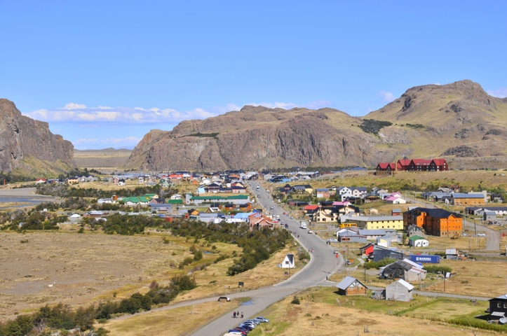
El Calafate and Glaciers

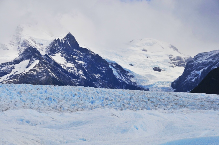
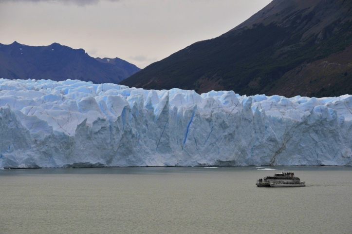
After our hiking in El Chalten, we headed to the charming village of El Calafate. The main reason for coming here is access to Los Glaciares National Park and Perito Moreno specifically. This is a UNESCO World Heritage Site and covers 600,000 hectares (and no, I don’t know exactly how big a hectare is. I just read that in the informational pamphlet we got on the bus). Suffice it to say it’s big and contains the third-largest ice field in the word, after Antarctica and Greenland.

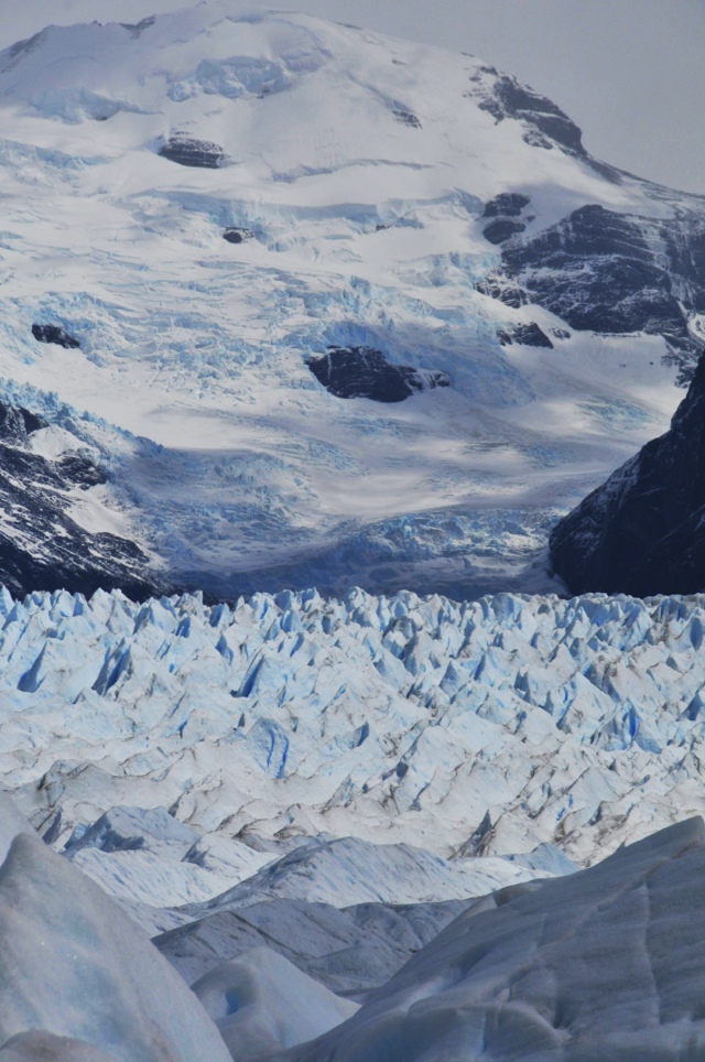
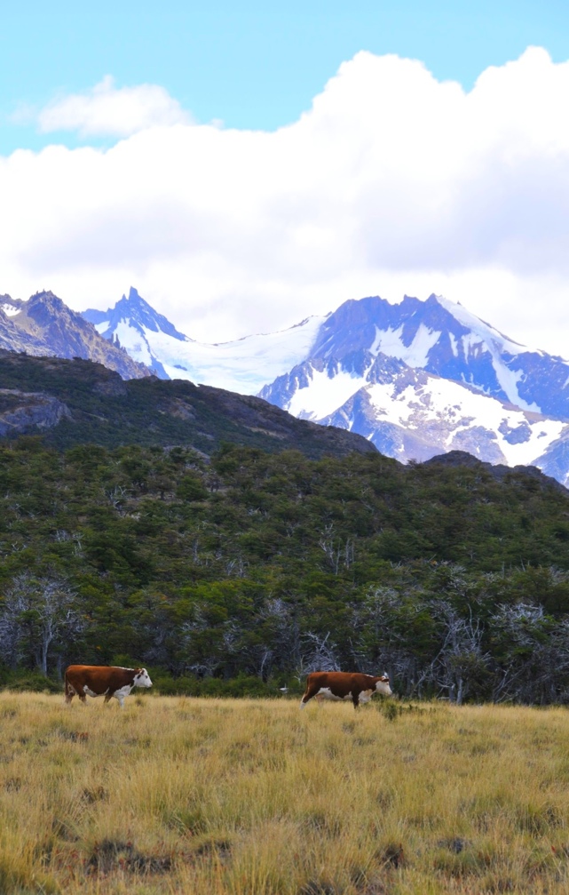
A sharp precipitation dropoff occurs east of the Andes because of the rain-shadow effect produced by the mountains. That means that while there are glaciers (essentially rivers of ice), the area does not get extremely cold, nor do they get much snow. They do, however, have several different habitats, including cold, upland meadows and woods where three species of trees grow. The driest habitat is the steppe, where plants adapt to the extremely dry conditions and very strong winds.

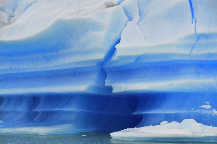
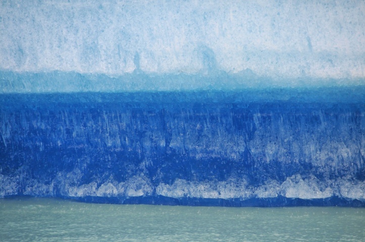
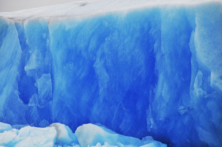
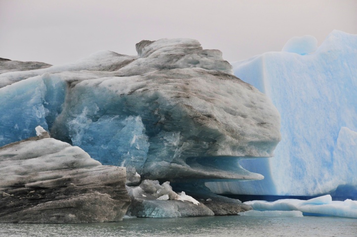
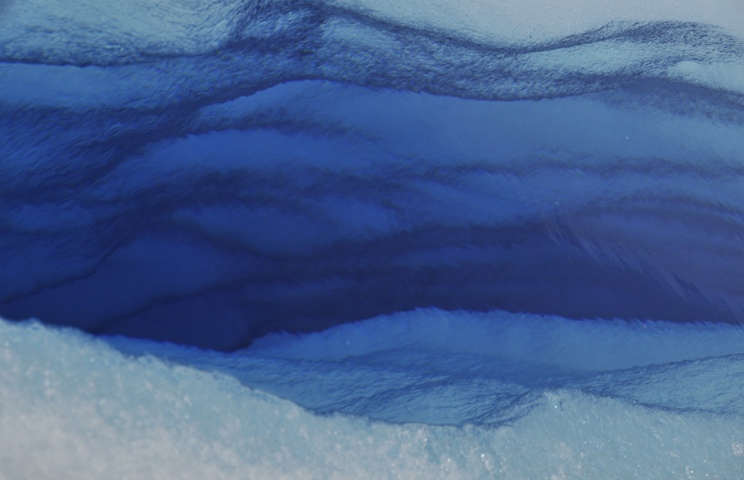
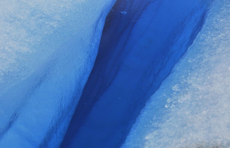
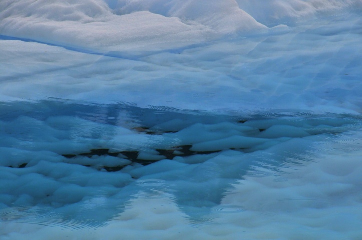
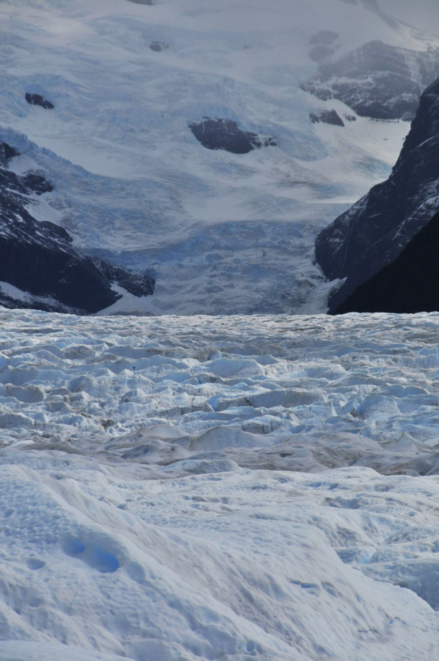
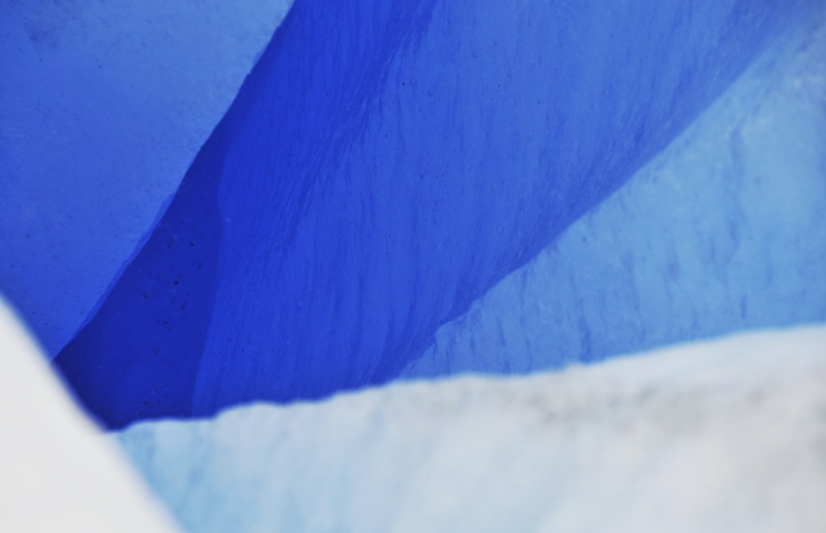
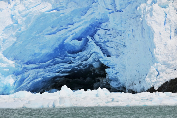
A few thousand years ago, glaciers covered most of the entire area of the Park. A glacier is essentially a very, very slow-moving river of ice. To give you an idea, the fastest glacier in the park, Uppsala, travels twelve meters a day, and Perito Moreno only two. A glacier is formed when layers and layers of snow are compacted to the point that they become ice. (The darker the blue color, the less oxygen and more dense the ice is.)

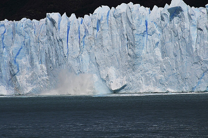
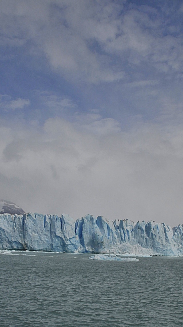
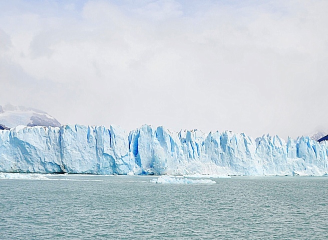
More snow falls on top of the ice, but all of the snow and ice retain the general shape of the land underneath it, hence the rises and falls on the surface of the glacier. Under all this pressure, the ice actually flows. When it reaches the lake (Lake Argentina, in the case of Perito Moreno), the face is easily over 100 feet tall. The glacier creaks and moans before ejecting parts of itself to the cold waters below. Because the size and location of these dislodged shards is unpredictable, boats must remain a safe distance from the face.

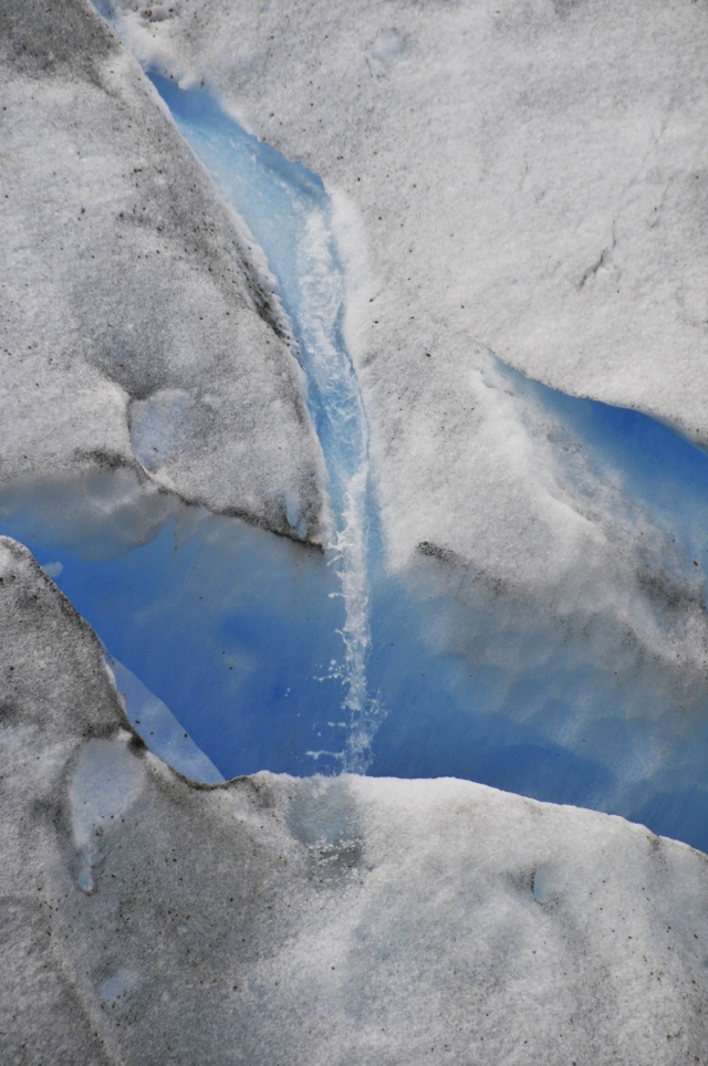
When the glaciers advanced, they eroded the land, creating steep valleys and depositing this material at the ends (and as they retreated, also to the sides). With the warming climate, the ice has retreated to the mountain areas where we see it today, and the valleys’ huge lakes are now much smaller in size. The water gets its turquoise color because it holds minute powdered particles in suspension.

One Day One, we took a daylong boat cruise to the faces of five glaciers, including Perito Moreno. The piercing white of the snow was tamed by hints of blue, at times in rich, deep hues. It was amazing to see those big walls of ice – and even more so to hear the creaking and try to predict where the pieces would crash. The glaciers look like a freeze-framed river, and if you hit the play button, you’d set a huge rush of raging rapids down the mountainside.

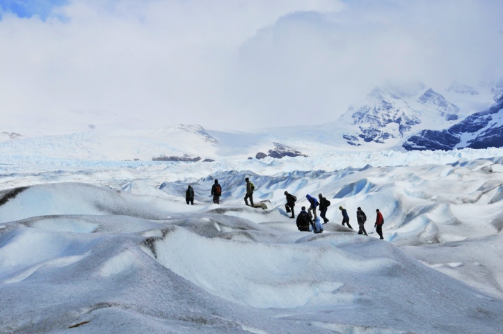
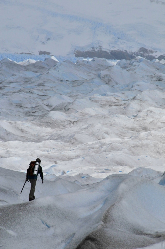
Our other El Calafate adventure was a day of The Big Ice. After observing Perito Moreno from the observation decks, we took a boat to the side of its face and hiked about 45 minutes to reach the stable part of the glacier. At this point, it was time to strap on our crampons. If you’ve never hiked with crampons, it’s a must. Crampons make you feel like Captain Badass. They fit onto your boots and have triangle-shaped metal spikes that dig in to the ice. You can march around on the snow and ice like you own the place. I first used them in New Zealand, and they’ve had my undying admiration ever since.

The landscape of the ice matched the topography of the earth and stone far below it, with folds, rolling hills, and slight bumps everywhere. By the time we hit the ice, the sun started peeking out, and the temperature warmed quite a bit. We peeled layers as we walked, and by mid-afternoon, we were down to a single long-sleeved shirt.

Walter was our main guide, and he was far, far handsomer than the name Walter usually suggests. No offense to the Walters out there, but the name does not typically appear in the same context with a chiseled, blue-eyed, Argentine mountain man. Walter kept the group together and led us along quite a stretch of the glacial bed, explaining the glacier’s formation and other information. He also told me about some of his climbs and showed me the mountains in the distance that he hoped to summit one day.

Toto was Walter’s compadre. His job was to go ahead to help steer the path and axe steps into the steep parts. He’d run across the ice, whizzing by us as if he were skipping across a backyard. He also assisted during the more dicey bits, like when I was straddle-crossing a very deep crevasse and psyched myself out. There’s nothing like looking down into a deep abyss between your legs, with twenty feet to go before you can put your legs back together to incite terror about becoming a cliche, made-for-TV movie. Toto jumped down in front of me, took both my hands in his and guided me by walking backward, having me look at him while he sang to me. He is, without a doubt, my hero.

A trip to Patagonia should be high on anyone’s list if you like to hike and/or just to see some incredibly gorgeous sites. We were reluctant to swap this gorgeous natural area for the heat and hustle and bustle of Buenos Aires, but alas, it was time for us to go.

20120224-172721.jpg

20120224-172735.jpg

20120224-172813.jpg

20120224-172754.jpg

20120224-172823.jpg

20120224-172835.jpg

20120224-172855.jpg

20120224-172921.jpg

20120224-172928.jpg

20120224-172943.jpg

20120224-173006.jpg

20120224-173017.jpg

20120224-173029.jpg

20120224-173042.jpg

20120224-173053.jpg

20120224-173115.jpg

20120224-173131.jpg

20120224-173147.jpg

20120224-173159.jpg

20120224-173217.jpg

Categories: Uncategorized | Tags: , , , , , | 1 Comment

Patagonia – El Chalten Trekking

Patagonia – El Chalten

El Chalten is a small town tucked away in a valley in Southern Patagonia, about 220 kilometers from El Calafate. El Chalten mainly serves as a base for trekkers and climbers, and offers the iconic views that are visually synonymous with Patagonia. The main mountain is Fitz Roy, named after the captain of The Beagle, whose now-famous passenger was the young naturalist Charles Darwin. Darwin accompanied Fitz Roy for five years to survey the flora and fauna of South America, which led to his famous theory of natural selection.

Fitz Roy is an imposing granite mountain with incredibly steep facings. Most of the time, it’s shrouded in some degree of cloud cover, which is particularly common for mountains in the area. Other peaks such as Solo and the Torres stand at its sides, but none are as stunning as Fitz Roy.

El Chalten sits within Glaciers National Park and bills itself as the National Trekking Capitol of Argentina. We bought a trails map that listed several hikes and were literally on our way. We did a total of four hikes, ranging from 5-8 hours long. The views were always impressive, and the weather gods smiled on us: we only had light rain and fog for part of the first day. The rest was mainly clear, and the hiking was fabulous.

The one thing we hadn’t been warned about was the wind. I haven’t looked up the typical wind gust speeds, but on some days, they were tremendous. The winds come in from the west over the Andes and down through the valleys. As such, they can pack a powerful – and cold – punch. While I have never been described as slight, I was literally knocked over several times. The sound was fierce. Interestingly, the wind disappears for winter, and I’m guessing that’s what helps make the place habitable: otherwise, it’d be a constant, unrelenting blizzard.

The first hike was to Laguna Torre, named after the mountains above that look like towers. It was incredibly windy, and as we got near to the lake (and where we would have seen the towers, had they not been socked in with clouds and rain), we were pelted with sand from the lake and riverbed. While always game for free skincare, we passed on the massive microdermabrasion and headed back since we weren’t going to get the view anyway. With five hours in our boots, we were still happy. That night, we ate at Patagonicus, which had some of the best pizza I have ever had in my life. We ended up going there three of our five nights. Heaven in pie form…

Day Two, we tackled the Laguna de Los Tres hike. Rain clouds loomed threateningly for the first hour, but by the time we got to the first mirador (lookout), they’d mostly dispersed. We had incredible views of Fitz Roy for the nearly the entire four hours we hiked in to the lake near its base. (The clear shots of Fitz Roy here were largely taken from this hike.) We also had clear views of a nearby glacier, and on the way back, we stopped for a rest at Laguna Capri. Sitting at the shores of a sapphire lake underneath an majestic mountain filled me with overwhelming gratitude for Mother Earth and Her abundant beauty.

By Day Three, we had our hiking legs, so to speak, so we opted for the Tumbado hike for a view from a bit higher vantage point. We started at 200 meters and steadily climbed to nearly 1500 meters (that’s 4900 feet, for us Americans, the only people in the world who still insist on an antiquated, nonsensical measurement system that’s even been abandoned by its creators). Above about 1200 meters, the only vegetation that could withstand the harsh winds was a small dome-shaped shrub, so the landscape was moon-like in appearance, with rocks and dust being the predominant inhabitants. We had a beautiful view of some of the mountains, as well as of the valley and lake below.

On the way back, we left a wooded area only to find ourselves in a field with cows grazing, ignorant bliss that they’d soon be famed Argentine steaks. One cow looked squarely at us and made a sound more accurately described as bleating than mooing and trotted our way. While I am a Midwesterner, I was a townie, not a farm girl. So when a cow runs toward me like a tortured bull in a Pamplona stadium, I get nervous. After what seemed like an uncomfortable amount of time, the cow veered away to join her herd. (She’d been yelling about a calf, who emerged from the woods minutes later). Relieved to not be under those one-ton hooves, we made our way back to town, triumphant to have conquered yet another big hike.

For our final trek, we branched out by taking a taxi to a location outside of town to trek to Laguna Electrico, at the face of the Marconi Glacier. Most of the path was in a wooded forest along a glacial stream. Soft breezes whispered through the trees, and it was as if we’d stepped into the pages of Thoreau. I found myself meditating on the pure joy of nature, and ideas about all sorts of things danced playfully in my mind.

After a couple hours, however, we had to leave the path and enter what would have been a glacial riverbed but was now mainly a field of stones. The scene change was profound, as the wind smacked us in the face and ripped at our clothes. We struggled to add layers of warmth and windproofing as we caught our first glimpses of the Marconi Glacier. We followed the ridiculously arbitrary yellow trail markers (did it really matter where we walked in a rock field?) and got as close to the lake as we could. Our path was impeded by streams running off the mountains to our right, and the glacier was now obscured by clouds and rain. We made our way back to the Enchanted Forest and agreed that this was, by far, the best way to spend a Sunday afternoon, sadly our last day in El Chalten.

20120224-171504.jpg

20120224-171525.jpg

20120224-171542.jpg

20120224-171555.jpg

20120224-171611.jpg

20120224-171626.jpg

20120224-171737.jpg

20120224-171752.jpg

20120224-171808.jpg

20120224-171821.jpg

20120224-171904.jpg

20120224-171947.jpg

Categories: Uncategorized | Tags: , , , | Leave a comment

Create a free website or blog at WordPress.com.